|
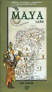
The ancient Maya inhabited a territory extending over 400,000 km2 in the Mexican states of Yucatan, Campeche, Quintana Roo, Tabasco and Chiapas; and the republics of Guatemala, Belize, and parts of Honduras and El Salvador.
The Maya Land map is a geographical representation of this area, showing highways, archaeological sties, natural beauty spots, historic cities and facilities, among other features, with appropriate illustrations of each place.
The
Map-Poster is printed on strong, quality stock and measures
36 by 26.5 inches. On the reverse of the map are the principal cities of the Maya World, with guide plans for the visitor to achieve a deeper understanding of this enigmatic world of magic and splendor.
Spread
it out and display as a beautiful poster decoration. When folded
it is compact enough to carry along your travels through the
Maya World.
|